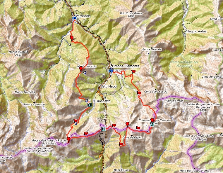
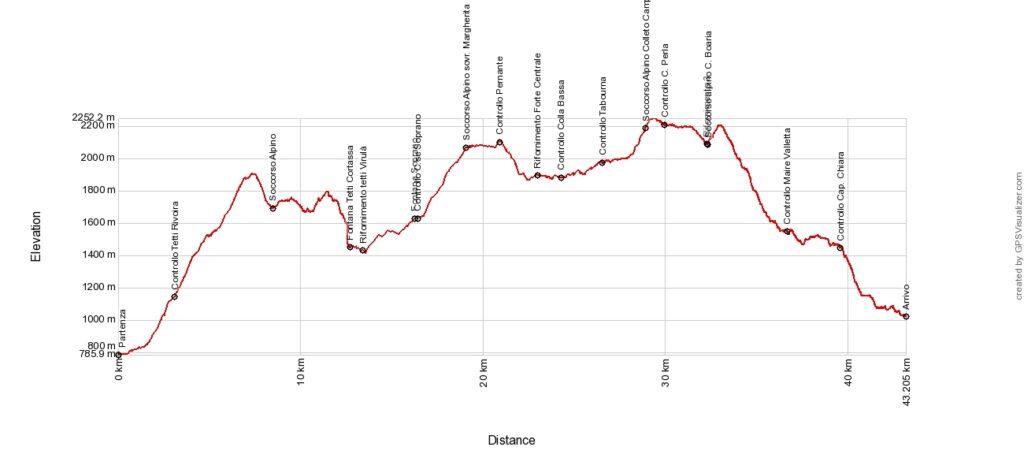
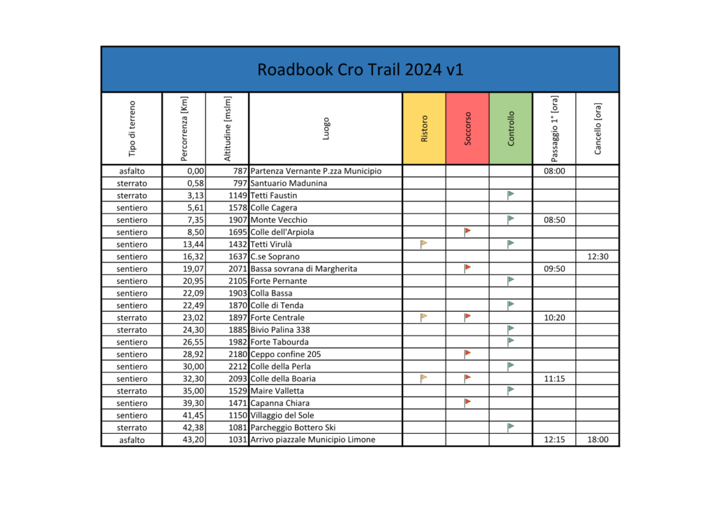
CRO WILD TRAIL 2022 ROUTE DESCRIPTION
Route description of the Limone / Tenda stretch:
The first part of the race between Limone Piemonte and Tenda (the first village in French territory that the athletes will cross), is characterized by the most important difference in height, from the thousand meters of Limone Piemonte, in fact, the 2100 meters of the Colle della Boaria. After starting in the central Piazza del Municipio in Limone P.te, proceed southwards until you take the Strada Romana until the first railway underpass on the left. Here you take the “Viasol” up to the hamlet of Fantino which travels for the most part along the railway line; then, continuing on the same path (L16 behind Campo Base), you reach Cima Buffe (1531 m) always on the “single track”. Crossing the ski slopes of the Riserva Bianca (towards the mountains) passing under the Alpetta chairlift, you reach Lake Secco in a fast descent and then Maire Valletta, starting point for Vallone San Giovanni (L15) through which you reach the Colle della Boaria seat of the water point N ° 1.
From Colle della Boaria, along the spectacular “cannon path” (GTA) always on the border line between Italy and France that travels parallel to the “Via del Sale”, you reach one of the many Savoyard forts of the late 1800s, Fort Tabourda ( mt 1985), passing first on Colle della Perla (post 326 mt 2212), then above Colletto Campanin (Becco Rosso mt 2241) post 337, following the path to the EAST you reach post 335. From here along the GR52A path, you it faces a very runable descent which, through magical pine forests, will take the athletes to the center of the small but lively French town of Tenda.
Route description stretch Tenda / La Brigue:
Once you enter the tent (880 meters) always from the GR52A path (behind the hospital) water point N ° 2, you leave the GR52A momentarily to immediately turn left and enter through the asphalted road in the nearby campsite and from here start the climb immediately ( towards pole 60) towards Colle di Boselia located at 1116 meters above sea level (pole 285). Always on single track which, as for the climb, is easy and “for those who can” run, along the “Vallon de Boselia” (towards pole 284) you reach La Brigue (860mt) (poles 49 and 50), a magical little village in whose central square there will be a water point N ° 3. ATTENTION: the few km of asphalt both in Tenda and in La Brigue are open to vehicular traffic, so be careful!
Description of the route la Brigue/Saorge:
The indications from the center of the Village of La Brigue, will take you to the Castle still in the village and from here you will take the GR52A up to the Basse de Peluna at 1265 meters (pole 245), then Basse di Gereon at 1252 meters (pole 251), then Basse di Lugo at 1487 meters (palina 207), therefore Fontaine de Ghiens h. 1485 mt (palina 204), Basse di Anan h. 1555 (palina 205). Here begins the descent on Saorge always on the GR52A, passing through the Pinée h. 857 mt (pole 433), ATTENTION: from the trough immediately to the left towards the Chapel of S.te Croix to reach the poles 163 and 162 and then the ancient Monastery that you will leave on the left and take a pavement up to the water point No. 4 of Saorge h. 515 mt.
Route description Saorge/Bresil sur Roya:
From the water point of Saorge you walk a few tens of meters towards the center of the Village and take a small staircase on the left (yellow notches Sentèe Valleen); then, a path that will take you touching the poles 19, 17 and 16, to cross the small rio de la Bendola after running a short stretch of paved road. Here you take the “Sentée Valleen” again touching the poles 156 and 155. From pole 155 you return to the GR52A, reached the pole 153 continue straight (ATTENTION not to the right) and touching the pole 108 you reach the pole 10. To the pole 10 ATTENTION! Turn to right (abandoning the GR52A), some steep downhill hairpin bends will take you up to the long Roya, from here to left until you enter directly into Breil Sur Roya (h. mt 294) at the height of the bridge of the D6204. Leaving the state road D6204 on the right, go along Rue Pasteur entirely, which crosses the entire town of Breil up to the ancient Chapel of Sainte Antoine where the water point N ° 5 will be located.
Breil sur Roya / Airole route description:
From the water point at the S.te Antoine Chapel, take the “Sentèe Valleen” always marked by yellow notches, a narrow path but easy to run, a continuous up and down with the pleasant view of the Roya river always on your right. ALWAYS FOLLOW the wooden poles indicating Libre / Fanghetto / Airole. Always remaining on the same path, you reach the 105 and 106 poles in succession to then enter the small village of Libre (h. 476 m) seat of the water point N ° 6, along a stretch of asphalted road (be careful!). From the central square of the Eglise, immediately on the left, you will find the 413 post after a few tens of meters, continuing along a few hundred meters of paved road up to the 412 post, from which on the right you take a downhill single track that between salts get off it will take you back to Italian territory (FI border marker stone pit) up to the town of Fanghetto h. 178 meters (Municipality of Olivetta S. Michele), a wonderful and characteristic village (post 410 in the direction of Airole). Once you reach the center of the small hamlet, you will find the water point N ° 7 under a portico. From the water point immediately left taking a paved climb that will take you through the village and then take the path that indicates Airole. Attention: from the moment you enter Italy, you will walk up to Airole the splendid “botanical path” also marked by white / red notches. You reach the Madonna della Grazie church located at the entrance of Airole on an asphalted road (pay attention) and still on the asphalted road after 400 meters you will reach the center of Airole h. 145 meters in the central piazza SS Giacomo e Filippo seat of the water point N ° 8.
Route description of the Airole / Ventimiglia section:
From water point N ° 8, immediately left, take the Mediterranean Path (white / red marks) which will take you to 755 meters of the Bassa d’Abellio after about 4.5 km (challenging climb in the second stretch). From the Bassa d’Abellio, after a few hundred meters on a steep downhill single track, take the Alta Via dei Monti Liguri at the entrance to which the last water point will be placed, N ° 9. From here on the right. The red and white notches that distinguish it (some with the initials AV) are evident almost to Ventimiglia. Dirt roads alternate with single track in a continuous up / down, some uphill stretches are not excessively long, but steep and demanding, very run down the descents. During the approach to Ventimiglia, pass the Passo del Cane (h.593), go around Mount Erisetta, cross the asphalted road of La Colla (h. 428) to get to Terre Bianche (h. 398), from here immediately steep climb of a few hundred meters but demanding, descent towards Ciaixie where you cross the asphalted road to take the last roughness that will take you to 428 meters below Monte delle Fontane. ATTENTION! During the descent on the dirt road, at Km 86.100, you leave the Alta Via dei Monti Liguri to enter the Rainbow Path on the right (dirt first and then single track), which you will follow until the entrance of Ventimiglia precisely near the Church of San Second. From here you will walk along Via San Secondo which you will leave after crossing the railway line on the bridge to take Via Chiappori which will take you directly to Piazza del Resentello (seat of the “CRO VILLAGE”) then turn right to arrive, after a few tens of meters along the Ventimiglia seafront, in the nearby free beach where the desired goal will be placed 20 meters from the shore !!!!
Cartography:
– Limone/Tabourda: Fraternali 16 – scala 1:25000 (Valle Vermenagna, Pesio, Parco Marguareis)
– Tabourda/Libre: IGN 3841 OT – scala 1:25000 (Valle Roya e Parc du Mercantour)
– Libre/Ventimiglia: Fraternali 23 – scala 1:25000 (Sanremo, Ventimiglia, Bassa Valle Roya)